
The Grad or hillfort of Nakovana, a most striking location and an important prehistoric site.
Probably, you have not heard of Nakovana before - if you have, you might just be an archaeologist with an interest in Dalmatian prehistory, or maybe you've been on a walking/hiking trip in Croatia's Pelješac Peninsula.
Nakovana is not (yet!) one of Croatia's famous archaeological highlights, such as Diocletian's Palace at Split or the Stari Grad Plain on Hvar, but it is a place of great beauty and of deep historical interest. It is not a single site, but a veritable archaeological landscape, reflecting many aspects of the region's early history, and beyond it.
Nakovana is located in the hinterland of Orebić, the medieval port town that is the population centre of the tip of the Pelješac Peninsula, a long and narrow spit of land protruding westwards into the Adriatic from the southern part of Dalmatia. Incidentally, Orebić is also well worth a visit, a lovely historic town with a Franciscan monastery and a number of fine historic 'Captains' Houses'. From there, it's just a short ferry-ride to Korčula Town on the island of that name, one of the most charming historic settlements in the area.
An upland plateau and two abandoned villages
But back to Nakovana. Just 8km (5mi) to the west of Orebic, or 2km (1.25mi) inland from the quiet coastal village of Viganj, the area is a small upland plain, about 270m (880ft) above sea level. Let's put it on the map for you (courtesy of Google - the Nakovana area is outlined in red - if you're seeing this on a phone, tilt it to see a wide-screen format):
Nowadays, Nakovana is uninhabited. A peaceful limestone plateau, certainly not barren but also not highly fertile, it is used only for herding flocks of sheep and goats. That's today, in an era of urbanism and regional rather than local economies. Until a few generations ago, people lived there and grew all kinds of crops - which is currently not economically viable, except maybe for olives and potentially vines.

Donja (Lower) Nakovana village, as seen from Nakovana Grad.
Nakovana is actually the name of an abandoned rural community, consisting of two villages, Donja (Lower) Nakovana in the heart of the plain and Gornja (Upper) Nakovana near its southeastern limits, both of which were inhabited into the mid-twentieth century. Going back to the Middle Ages, this community existed for many centuries. Today, both villages are mostly ruined, with only a few houses maintained for occasional occupancy. Some of the former inhabitants' descendants now live in the various coastal settlements nearby, among them Orebić, Viganj and especially Lovište; others emigrated to places much further afield, including Argentina and New Zealand. The stone-built remains of the two Nakovanas are atmospheric places, evoking the long-departed lives of the past and also exemplifying the architectural traditions of their erstwhile inhabitants. The name Nakovana is related to the Croatian word nakovanj, meaning an anvil, but it is not known why.
A hidden past
The villages are 'recent' archaeology, for sure, but not particularly exceptional: you can find such abandoned places in many places of upland Dalmatia, and they all reward exploration. What makes Nakovana truly remarkable, however, is its more distant, prehistoric, past. The seemingly empty limestone plateau has a hidden story and archaeologists have revealed some of it!

The stand-out feature of Nakovana is the Grad or hillfort, dominating the plateau and - as archaeological research has shown - a place frequented by humans thousands of years ago.
A visually exceptionally striking feature dominates Nakovana, namely a large, steep-sided and flat-topped limestone outcrop that is located near the centre of the plateau and towering 40m (130ft) above it. The locals call it grad. Walking in the area, your gaze keeps veering towards it. Personally, I suspect that it's the figurative anvil that gives the area its modern name. If you're an archaeologist specialised in prehistory, the outcrop is the kind of place that makes the hairs at the back of your neck stand up at first sight - and rightly so. It has been a focus of human activity more than once in the distant past.
Archaeological surface survey has discovered very ancient fragments of pottery and stone tools on it. They show that the outcrop was first settled a very long time back, in the Neolithic, probably well over 6,000 years ago, when the first farming communities came to this part of the world. Settlement appears to have continued throughout the Bronze Age.
An Illyrian Hillfort
That was only the beginning. Thousands of years later, between 2,400 and 2,000 years ago, the outcrop was the region's political centre - an Iron Age Illyrian hillfort. Let me explain.

A map of the territories occupied by Illyrians, as identified and placed by Greek and Roman writers, with the Latin names of individual tribes marked (modified from an original by Wikimedia user MaryroseB54 / CC BY-SA [https://creativecommons.org/licenses/by-sa/4.0/]). The red dot (our addition to the image) marks Nakovana. Please note that the topic of ancient Illyrians and their historic roles and locations is mixed up in various modern political controversies, none of which are relevant to this post.
During the first millennium BC, most of southern (coastal) Croatia, or Dalmatia, was inhabited by the somewhat mysterious people(s) we now call the Illyrians (it's not their own self-identifying name but the one they were given by the Ancient Greeks - unfortunately, the Illyrians themselves have not left behind a written record). As far as we currently understand, the Illyrians were not a single people, but rather a group of peoples that lived in parts of the southwestern Balkans, including the Delmatae, whose name gave rise to that of Dalmatia. The Illyrians apparently spoke an Indo-European language of which we know little (some scholars believe that modern Albanian is derived from it), and they were organised on the basis of tribes or 'chiefdoms', a system that was - broadly - similar to that of the Iron Age Celts in Central and Northwest Europe, the Ancient Germanic tribes in Northern Europe, the Italic forebears of the Romans in Italy, or the Geometric-era (that is Early Iron Age, pre-city-state) Greeks. A standard form of organisation: tribal, with a warrior aristocracy, what archaeologists sometimes describe as a 'big-man society'.
In much of Western and Central Europe, the power centres of such Iron Age warrior societies are what we now call hillforts, locally prominent rises or indeed hills that were defensible and that commonly dominate their surrounding areas. Often, the natural features of such places were modified by human hands to make them into fortifications. Depending on importance, hillforts range from fairly modest places, significant only for a small area, to massively monumental ones, dominating entire regions and transformed through generations of labour into vast fortresses, examples including Maiden Castle (in Dorset, England), the Heuneburg (in Southern Germany), or Bibracte (in Burgundy, France), to name just three very famous (Celtic) ones. The Delmatae were not Celts, but the same type of local organisation applies to them.
Such places were the residences, the final refuges from attack, and the ceremonial centres of regional entities: local tribes, who chose whatever site was convenient as their focal centre. In Croatia, such (Late) Iron Age hillforts, of which there are hundreds or even thousands, are normally known as 'grad' (plural 'gradine'), an old Slavic word denoting a fortified settlement.
Archaeological exploration

A vaulted water cistern near the top of the Nakovana hillfort. This archaeological feature is immensely informative. It indicates knowledge of fairly sophisticated architecture (a barrel vault) and also underlines the need for water supply, necessary for the site either as a residence or a fortification, or both.
The Grad of Nakovana is such a place. Although it is not a super-site like the ones mentioned above, it fulfils a similar role in its area, the western end of Pelješac, and it is a top-scale site of its type in Late Iron Age Dalmatia. It has all that's required. Nakovana Grad is surrounded by tall cliffs, making it easy to defend, and the only natural access to it was protected by built walls, bits of which can still be made out. The site dominates and thus controls its surroundings, which provide water and arable land as well as grazing for livestock. It is located conveniently away from the shore, making it safer from naval attacks or raids, but close enough to give easy access to a series of natural harbours located on what were busy sea-lanes, key arteries of trade and contact at the time (the coastal tribes among the Illyrians were famed seafarers and shipbuilders).
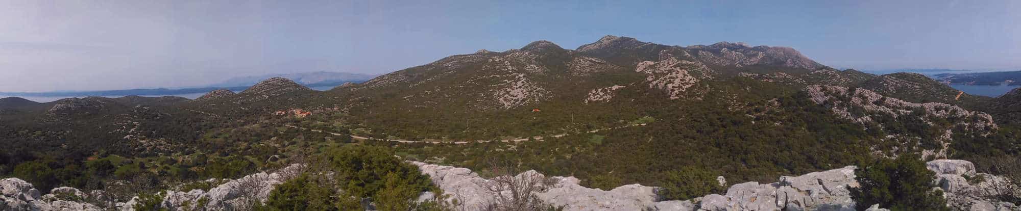
A panoramic view from Nakovana Grad, taking in the upland plateau, the sea to the north (left) and southeast (right), as well as the villages. The cave is located just above the image's centre.
Beyond those most visible aspects, systematic archaeological survey on the Nakovana Grad has revealed more. Apart from the defensive walls, there are remains of other built structures, among them an artificial water-cistern and the stone foundations of several buildings, the functions of which cannot now be ascertained - but architecture in stone was fairly rare and thus meaningful at the time. To this day, vast amounts of sherds, fragments of ancient pottery, are scattered on the plateau and its slopes, including pieces of coarse locally-made cooking and storage vessels, but also those of finer wares. Many of the latter are clearly of Greek manufacture - imports from the Greek settlements on some of Dalmatia's islands, perhaps also from further afield.

An iron age burial mound (tumulus) at Nakovana, with the hillfort in the background.
The role of Nakovana Grad in its Iron Age environment extends beyond the outcrop itself. The area of the plain immediately surrounding the Grad and especially to its north, where the more fertile land is located, contains over fifty tumuli or cairns, artificial stone mounds that are ancient grave markers. None of them have been excavated so far, but they indicate that the area was considered an appropriate place for the burial of important people, most likely the aristocracy of the era and the time - the people that lived or assembled on the Grad. Such tombs, too, are standard in European Iron-Age warrior societies.
We have no written sources that describe who lived in Nakovana during the last few centuries BC, nor what exactly happened there, so we cannot possibly conjure up a detailed history of the place - we don't even know what either the area or the hillfort were then called. External, Greco-Roman, sources identify the people who dominated the area as an Illyrian tribe they call the Pleraei (in Latin, or Pleraioi in Greek), and they also state that those people were engaged in piracy (then a common 'trade' around much of the Mediterranean coastline). From archaeological and historical sources, we know that these local tribes interacted with the Greek, and later the Roman, presence in their vicinity in various ways, sometimes in a more warlike fashion, more often trading with their new neighbours...
A sacred cave

The entrance to Nakovana Cave.
There's more. The archaeology of Nakovana includes another prehistoric site, and one of a much rarer type: Nakovana Spila, the Nakovana Cave, located above the plain, just 1km (0.62.mi) north of the Grad. It has been known as an important Neolithic site for many decades, indicating settlement going back to the Early Neolithic, 8,000 years ago. That would be important enough, but during an excavation in 1999 the archaeologists Stašo Forenbaher (now professor at Zagreb) and Timothy Kaiser (now professor in Ontario) discovered a passage to a hitherto unknown chamber. It is one of the most significant finds of Dalmatian archaeology in recent decades: an undisturbed Iron Age cave sanctuary or cave shrine and thus a regional religious centre, a sacred place!

Copies of two plaques from the zodiac board, depicting Gemini and Cancer (on display at Viganj).
What it contained was an enormous deposit of (mostly broken) pottery: tens of thousands of fragments belonging to the same Late Iron Age date range as the sherds seen on the Grad: the fourth to first centuries BC. The assemblage is, however, a much more unusual one, as two thirds of it consist of fine wares, pieces of vessels used when serving or consuming food or drink (i.e. plates, jugs and cups), especially wine. Moreover, virtually all of these fine wares are Greek imports, some from the Greek settlements off the Dalmatian coast, and many from Greece herself, much further away. This does not mean that the cave itself was frequented by Greeks - more likely it was used by locals who had access to such valuable material and were willing and able to 'invest' some of their wealth in this place. Quantities of animal bone were also found. Perhaps the most intriguing artefact, however, was a series of small ivory plaques, finely engraved with what appear to be the signs of the zodiac. They are part of a Greek astrologer's toolkit, a rare and valuable item.

A restaurant at Viganj displays a simplified and fanciful version of what the central sanctuary in Nakovana Cave may have looked like, with replicas of Greek vases and fruit offerings arranged around the centrepiece in lieu of the stalagmite.
Many of these objects were found deliberately placed around a highly distinctive stalagmite, a large limestone upward protrusion, located in the inner chamber in such a way that light from the entrance would reach it at certain times, enhancing it. The shape of the stalagmite is - let's say - suggestive, or to be clearer, phallic. Unfortunately, we know next to nothing about the Illyrians' religious beliefs and practices, but the evidence at Nakovana Cave gives us three key aspects: a) what happened in the cave justified the regular use and destruction of valuable, 'exotic' materials, b) large quantities of food and drink were consumed in or near the cave on repeated occasions, and c) concepts of virility, of male fertility or sexuality, were significant to these events. From that we can conclude at best that a male deity was worshipped. In a Greek context, it would suggest either Dionysos, god of wine and ecstasy (and many other things), or Pan, god of flocks and mating (and also many other things), but it's harder to assess this question in a Dalmatian context. In Roman days, the Dalmatians worshipped a deity called Sylvanus, who had features of both Dionysos and Pan. Ancient religions are complicated, especially when they're not mainstream. We cannot know quite who was worshipped in Nakovana Cave and maybe it's not the right question to ask. It was a god for whom feasting and offerings to a phallic stalagmite were appropriate acts of worship. It'll have to do.
A Dalmatian seat of power and centre of identity
It is not that hard to imagine the Nakovana Grad as the political and ceremonial centre of a tribe settling this part of Pelješac.

Another view of Nakovana Grad, with another burial tumulus in the foreground.
A population of farmers, herders, fishermen (and so on), scattered in the area, would have 'looked up' to this focal place. This was where their ruler (a local king or queen or both, or the equivalent of a local chieftain) resided with their warriors and entourage. Here, they held court, representing and dominating the surrounding communities, overlooking the land and seas under their control. At times of danger, people would retreat to the hillfort and the protection of their tribal 'family', and perhaps they would also assemble there for 'special' events or observances. Every now and then, one of these rulers or another prominent aristocrat or warrior was laid to rest in the shadow of their stronghold, their passing celebrated and mourned ostentatiously and memorised by a stone monument. Nearby was a sacred place, a cave that was known to exist by all but that was inaccessible to most, and thus a place of mystery, imbued with stories of the past and of the rulers' ancestry. There, some members of that Iron Age society repeatedly assembled to engage in acts of worship and feasting, thus expressing their identity and allegiance.
It all suggests the idea of a landscape imbued by its inhabitants with specific meanings and stories, the very landscape becoming part of their tribal identity.
A violent end?

Terrible things happened to the people of Korčula and Mljet in 35 BC. Here are both of them, as seen from the road linking Nakovana with the coast: Korčula (with its famous medieval peninsular town) in the centre, Mljet in the distance...
Activity on the Grad and in the cave appears to have come to an abrupt halt late in the first century BC, and the same applies to the wider surroundings. We cannot be sure, but the historic record suggests an explanation. The Romans had been fighting the Illyrians on and off since the 220s BC. In the 30s BC, Gaius Octavius, establishing himself as the Roman strongman (he was to become the highly-revered first emperor Augustus), engaged in a series of military campaigns in the area, ostentatiously 'punishing' the Dalmatian tribes for their rebelliousness and piracy. For 35 BC, the historian Appian reports as follows:
Others which had revolted, the Meliteni and the Corcyreans, who inhabited islands and practised piracy, he destroyed utterly, putting the young men to death and selling the rest as slaves. He deprived the Liburnians of their ships because they also practised piracy. (Appian, Illyrian Wars, 4,16)
Those Meliteni and Corcyreans were the inhabitants of the islands now called Mljet and Korčula. The former is 30km (19mi) away from Nakovana as the crow flies, the latter only 4km (2.5mi)! Most likely, the Illyrian inhabitants of Nakovana fell victim to the same massacres. After further violent struggles, Dalmatia eventually became a peaceful part of the Roman Empire, and some parts of the region thrived - Nakovana is not one of them. It appears to have been abandoned for nearly a thousand years.
An archaeological landscape

In the ruined village of Donja (Lower) Nakovana.
I am sure that future excavations will still reveal more about the past of Nakovana. What we have for now is already impressive: a scattering of sites illustrating over eight millennia of human activity, from Neolithic to recent, and an Illyrian landscape of power, of life and death, of worship and celebration as well. All of that, embedded in a remote and beautiful landscape. Even though we have lost the names of those who dwelt here and their individual stories, the myths and legends that must once have been attached to the area and the places within it, we can still tie them into a wider story of Pelješac, Dalmatia and the Balkans in the European Iron Age and beyond.
Our Dalmatian coast cruises include many highlights, including the Nakovana area on foot on Peter Sommer Travels' Walking and Cruising Southern Dalmatia (but note that the interior of the cave is not usually accessible), and our tour experts are eager to show you what there is to be seen, based on the most up-to-date research!


Leave a Reply